
The Marine Electronics Hub

- Fishing & Sonar / Wireless & Apps

Digital Yacht Sonar Server, keeping it simple!
by Ben Ellison · April 20, 2015
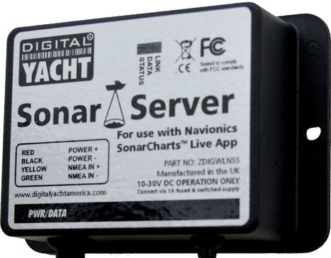
I’m really impressed with the Digital Yacht Sonar Server introduced last week , though it has almost nothing to do with the technology involved. In fact, I think the DY developers could have engineered this product in their sleep, as could several other companies that specialize in NMEA 0183 utility hardware. What’s brilliant here is a simple, reasonably priced, and fast-to-market solution for certain boaters who are understandably hot to use the Navionics SonarCharts Live app feature on their phone or tablet. And Digital Yacht has backed up their marketing smarts with deep info on how to install the Sonar Server…
It’s no wonder that many boaters are confused about SonarCharts, as they’ve evolved in many directions. Navionics started talking about user-generated depth charts as UGC 3D back in 2012 and rolled the idea out as the SonarCharts layer a couple of years ago. They became an optional view for many regions of the Navionics mobile apps — which all became Navionics Boating with free and in-app chart purchases early last year — and now they’re included with almost every type of Navionics chart card, at least for many regions, though they don’t necessarily display on all plotters that can show regular Navionics charts. At first, contributing your own data to SonarCharts was a complex task that involved recording track or NMEA data files, taking your Navionics card home to upload them, and then bringing it back later to download the freshly processed SonarCharts containing your soundings.
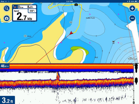
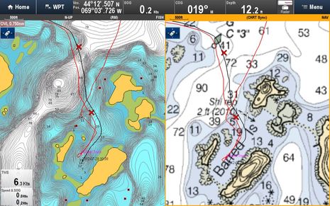
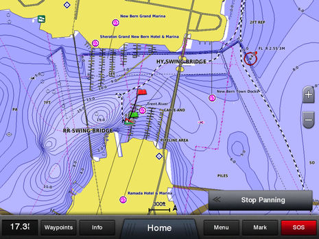
Last year, Navionics and Raymarine made that process a whole lot easier with a special form of Plotter Sync that integrates the Boating app with current Raymarine WiFi multifunction displays, though you need Freshest Data subscriptions for both platforms (and it only works with iOS Boating so far). That’s when I started seeing how SonarCharts could improve cruising (like in the Barred Islands above). Then Navionics announced that the Vexilar WiFi sonar products would be integrated with their apps , which turned out to include the SonarCharts Live option I enjoyed testing in January (above). Only recently did Navionics make a version of SonarCharts Live possible using simple NMEA 0183 depth messages broadcast over WiFi .
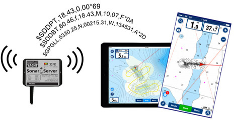
That’s what is being neatly illustrated above using DY’s new $120 Sonar Server. Note that GPS can also be included if your phone or tablet doesn’t already have it, and that this form of SonarChart Live can only show live depth, not the fishfinder window possible with the Vexilar connection. But this app feature will be as easy to use as I found the Vexilar — Navionics Boating will simply enable it when it sees the Sonar Server (or similar) on WiFi and upload the data for processing into actual SonarCharts when it sees the Internet — and Digital Yacht has created a dedicated SonarServer.com site to make the install as easy as possible.
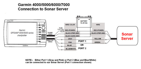
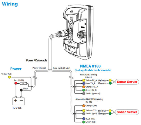
Digging down into the Sonar Server Knowledge Base , you’ll find an amazing amount of well-presented detail about how to set up 0183 output on all sorts of displays, including older ones, and how to connect the not-color-coded wires. If, say, you want to collect sonar data to Navionics SonarCharts on your mobile but not mess with the Navionics/Garmin card fracas (good choice), there’s one of several possibly useful DY diagrams above. And while I’m looking forward to soon testing Navico’s much simplified sonar/chart uploading/downloading system (and comparing Insight Genesis Social Mapping to SonarCharts), any boater with some sort of Navico sounder like the Lowrance Elite 4 below can probably use SonarChart Live fairly easily. (I’ll also try GoFree, Vesper XB8000, and other forms of NMEA-over-WiFi data with the latest Navionics Boating apps, as many may work as well as the Sonar Server.)
But simple and easy are really important. I may spend my work life deep into marine electronics, and many commenters here are similarly inclined, but average boaters are terribly confused by marine electronics, particularly the bleeding edge stuff like recording sonar and putting boat data onto WiFi. So a big tip of the hat to Navionics for making community-sourced sonar charting fairly easy (the open source folks should pay attention) and to Digital Yacht for focusing their considerable resources on a crystal clear solution to a very specific issue.
Related Posts:
Ben Ellison
Panbo editor, publisher & chief bottlewasher from 4/2005 until 8/2018, and now pleased to have Ben Stein as a very able publisher, webmaster, and editing colleague. Please don't regard him as an "expert"; he's getting quite old and thinks that "fadiddling fumble-putz" is a more accurate description.
19 Responses
- Comments 19
- Pingbacks 0
Ben, I think I am one of those you mention as not understanding marine electronics very well. I am interested in being able to create/record breadcrumbs with corresponding depth readings on an iPhone or iPad chart. I think this is what this article addresses – correct? (Intended use is to scout and identify a route or anchorage with appropriate depths that would be safe for the mother ship).
Bruce This is potentially a great application for SonarServer and the Navionic’s SonarChart Live capability. Connect the SonarServer to your tender’s NMEA depth system (sounder, fishfinder etc) and real time depth data is sent to the Navionic’s Boating App on a tablet. The new bathymetry will be displayed on the tablet and the chart redrawn with the new data. You can then use this on your mother ship Once the tablet has an internet connection, the data is uploaded to Navionics who make the data available for the community and once validated will republish on their official “sonar charts” capable of displaying on traditional plotters Hope this helps
Hi, you mention in your article that you were going to try the GoFree, Vesper XB8000, and other forms of NMEA-over-WiFi data with the latest Navionics Boating apps. I have a nmea to wifi bridge, and it works great in other apps, though I can’t get it going in the Navionics app for Sonarcharts live. I’ve queried Navionics about what NMEA sentences the apps supports, and what port it is expecting to see NMEA data on, though they said they only support their partners hardware. I am sending GPS and Depth data via NMEA, and I assume that is all the app needs. Has anyone out there got a Sonar Server, and want to give up the NMEA sentences that it outputs, and on what ip port?
I got the same response form Navionics. It’s a bit odd as I’d have thought they’d have wanted as many users as possible to use the functionality they’ve coded. From this thread on the kplex discussion group: https://groups.google.com/forum/#!topic/kplex/v0E72seSlhI I’m guessing that Navionics are using a combination of bonjour (using the services that navico and vesper advertise) and a list of addresses/ports used by partners
Hi Ben, looks like a handy little gadget. But a few questions if I may: 1) how are NMEA “collisions” handled over WiFi? With data flowing from (increasingly) WiFi-enabled sensors such as sonar, AIS, radar, heading, etc., I am concerned that this data may suffer similar effects to traditional 183 streams. Is some kind of “WiFi multiplexer” needed here? I know DY and many others offer WiFi multiplexed bridges, but it seems they are pushing this specific device, as are others. I am concerned that proliferation of all of these WiFi devices are going to cause additional issues… 2) how is the Sonar Server here different from, say, a vanilla serial to WiFi bridge? Is there special encoding/conditioning of some kind done on the stream on it’s way to apps such as Avionics, perhaps special ports or signals? Thanks, Drew
Drew, I’m not an IT expert but I think that WiFi bandwidth hugely exceeds NMEA 0183 serial speeds and data loads. I’ve also never seen any issues with the many 0183 over WiFi connections I’ve tried. As for question 2, I don’t think there is much technical difference, if any. The point I tried to make is that DY is smart to market a device to do a very specific task and back it up with clear and specific install instructions so that most anyone can pull it off.
I managed to get sonarcharts live working with an off the shelf serial to wifi bridge, much cheaper than any officially supported navionics product. Details are here http://stripydog.blogspot.com.au/2015/08/navionics-sonarchart-live-on-android.html?showComment=1445341602886
Drew, Regarding the first question…depends what you mean by “collisions”. Your question could be taken on many levels, some of which have a simple answer but others are pretty interesting and worthy of a blog post rather than just a comment. Ben is completely correct in saying that even 802.11 operating at basic rate can accommodate many NMEA-0183 sources which answers the question on one level. On another level, yes, 802.11 implements collision avoidance. The more interesting question is what if we have multiple NMEA-0183-to-IP sources on a single network. There’s no “standard” for this stuff (other than IEC-61162-4 which isn’t what we’re talking about here) which makes things interesting. Generally people buy one multiplexer which they stick a bunch of serial lines into, the software is responsible for multiplexing those inputs to a single wifi output and applications read that, either over UDP or TCP. That’s no problem (see Ben’s comment). If you have multiple wifi sources though, what then? If you’re using TCP, OpenCPN can handle multiple TCP data streams, but if your app can only handle one TCP input you need something to multiplex multiple TCP sources. If you’re using UDP and everything is sending to one port you’re fine if the sender puts only complete sentences into a single datagram but a bit stuffed if multiple senders are using UDP as a stream. The joys of non-standards…. With only a single wifi nmea source you shouldn’t need a “wifi multiplexer” (as opposed to a multiplexer which outputs wifi: subtle difference) and the need for such a thing should be pretty minority but if you *do* need one….the free kplex can do that for you (and service your other multiplexing needs) Regarding the second point…talking to the Digital Yacht folks at a recent boat show the SonarServer doesn’t do anything different from an NMEA-0183-to-wifi bridge (but seems to be cheaper than many of them). Does it do anything different from a pure serial to wifi bridge like discarding packets with bad NMEA checksums? I don’t know but per the link Snapper provides Navionics is happy with simple NMEA-0183-over-IP on UDP port 2000 (which is what the DY product broadcasts)
This device is just old wine in a new bottle. And yes I am biased, I am the manufacturer of the MiniPlex-2Wi (amongst other multiplexers). And I am also disappointed in Navionics. In the past, they have tested the MiniPlex-2Wi with their app and for a reason beyond my comprehension, they decided not to support it. In fact, Navionics only offers a selection of pre-programmed NMEA servers. They left out an option to enter an arbitrary IP address and portnumber. And this is very annoying because I receive a lot of e-mails from customers who bought our MiniPlex-2Wi AND the Navionics app, only to discover that this app does not allow them to use any other device than the ones offered in the app.
Sorry to hear that, Meindart, but did you check out the “stripydog” link provided above by Snapper? It seems like stripy figured out several ways to get the Navionics apps to recognize NMEA data coming from most any server. It seems like Navionics’ intention is to make the WiFi link super simple, and it is with Raymarine and GoFree access points. The latter is looking particularly good with boat depth and position showing on the app and SonarCharts Live running well. But I do wish that Navionics would put in the IP address option you mention. Why not?
Hi Ben, I will see if I can get the MiniPlex-2Wi recognized using Snappers information and add this info to our web site and manuals. I am surprised to learn that Navionics uses port number 10110 for NMEA, while they refused to add our product (the MiniPlex-2Wi) to the app. I probably should have told them that it was I who registered port 10110 with IANA…. funny Italians 🙂
Funny, right now I’m watching a Navionics Webinar titled “Smart & Wireless, now it’s easy!” http://goo.gl/Br55p0
I read your article with great interest as I am a pretty technologically saavy person who is suffering thorugh the proprietary nature of marine electronics. I have an old raymarine chartplotter with a raystar 120 GPS. I was having some problems with the fix so I got a hold of the Navionics app for iOS and am loving it. I especially like the autorouting. My question is how I can support that setup at the least expense possible. It soulnd like this is the solution with the app fed by the raystar with or without the chartplotter. The only other question I would have is what if anything I can do with my smartcraft/vessel view feed from my twin engines. I have that on a separate display now but would love to get that to the table as well. Thanks
Hi Pete, There are many, many ways you can get boat data into your iPad via WiFi or Bluetooth but it’s darn confusing. Fairly simple NMEA 0183 data like GPS is relatively easy, NMEA 2000 (usually converted to 0183 en route but can be much richer) harder, and big data streams like sonar or radar the hardest. The apps also vary a great deal in their capabilities. Navionics, for instance, works well and automatically with certain sources but has no facility for specifying the URL and Port of a source dev ice it doesn’t know. There’s lots about this scattered around on Panbo — try the site’s internal Google search — and a good list of sources devices is maintained by the good folks at iNavX http://inavx.com/faq I, too, am a big fan of Navionics Dock-to-Dock autorouting: https://panbo.com/archives/2015/12/autorouting_navionics_new_dock-to-dock_kicks_it_up_a_big_notch.html
Hi, Great article and very timely. I have been using the Navionics app with auth-routing on my iPhone for a couple of years now but would love further integration with my existing chart plotter/fish finder. If I understand this correctly, I can feed the 0183 data stream from my plotter to this server and that will serve up current data to my iPhone Navionics app live? Can it interface more than one 0183 device? My goal is to ultimately integrate my SmartCraft 5000 and charting info into a single tablet based information center. Pete
Pete, This unit has only one NMEA input/output at a fixed baud rate. If you need to feed more NMEA 0183/2000 sources, you need a multiplexer with WiFi capability.
Does anyone know if the GPS location will be available to all apps on the iPad or is it specific to Navionics? I have a wifi-only iPad that I would like to use for a backup plotter but it already has Garmin Bluecharts Mobile on it, as well as a variety of other apps (like anchor drag) where GPS location would be useful.
Jack, Any app can use the GPS data delivered by ths unit. You only need to set your app of choice to UDP and set the port number to 2000. That’s all. If your app asks for an IP address, I think it’s 192.168.0.1 here but as long as our app only listens to NMEA, any address will do.
Is there any way to make the connection with cables without using Wifi in between ? I would llike to up/download the sonar chart logs from my Lowrance Hook 7 over 4G to Navionics servers. I have Android and Linux computers in my boat and have many times connected different kind of NMEA0183 devices to all my computers.
Join the conversation Cancel reply
Your email address will not be published. Required fields are marked *
Save my name, email, and website in this browser for the next time I comment.
Don't subscribe All new comments Replies to my comments Notify me of followup comments via e-mail. You can also subscribe without commenting.
Editors' Blog

David Burch wants to educate us about Electronic Navigation Charts (ENC)

Panbo(at) gets more stable: Seakeeper 1 install in progress

Epoch’s new 460 amp-hour, external communicating battery arrives and testing begins

METS 2023: EPT Technologies solid-state battery destruction demo

Gizmo’s new (though previously owned) compass, thanks to Max Marine Electronics
Join our list and be notified of new posts, subscribe to panbo.
Subscribe to Panbo to be notified of new posts and content
Press Releases

Recent Panbo Comments
Recent forum posts.
RE: Tablet for aquamaps
Bryan, The tablet I mentioned is the Orca Display...
By Ben Stein , 17 hours ago
RE: Reverse engineering Mastervolt Master Adjust protocol
@nburrell - I understand this is an old thread, but wou...
By Sidney Fung , 2 days ago
RE: Portable Power Station
I think to use a portable power station like the Bluett...
By Laurie Andersen , 2 weeks ago
Tablet for aquamaps
Ben, At the AGLCA rendezvous I believe it was you tha...
By Bryan Verhulp , 2 weeks ago
RE: Can't make my Yacht Devices engine gateway see my Volvo Penta D12s
I couldn't find a way to post the photo here, but it's ...
By stubb zord , 1 month ago
RE: Man overboard
Dan - Yes exactly this would be absolutely ideal. Just...
By Tom Moore , 2 months ago

- BOOT PORTAL /
- Media & News /
Navionics SonarChart™ Live now compatible with any sounder via Wi-Fi - Real-time chart generation tool expands list of compatible plotters and sounders to allow all boaters to wirelessly monitor impro
Navionics s.p.a..

Navionics, the leader in content and location-based services for the recreational boating and outdoor markets, has recently expanded compatibility of its award-winning SonarChart™ Live to include Raymarine Dragonfly PRO and Wi-Fish systems. SonarChart™ Live is available for free with the Navionics Boating app for iPhone and iPad, and for Android smartphones and tablets.
With SonarChart™ Live, boaters can connect GPS chartplotters, sounders and fishfinders with their mobile devices using Wi-Fi and view an HD bathymetry map in real time while navigating. Raymarine Dragonfly PRO and Wi-Fish users can also view charts and CHIRP DownVision in split-screen within the Navionics Boating app.
SonarChart™ Live is also now available for use with any sounder or plotter connected to a compatible Wi-Fi router, such as Digital Yacht’s Sonar Server. Once a device is connected via Wi-Fi to Navionics Boating, sonar data is streamed to the app to instantly create and display a personal SonarChart™ Live map layer on top of existing charts. Boaters simply engage the GPS and watch as the new HD detailed bathymetry chart reveals the shape of the sea floor with detailed bottom contours in real time as the boat moves across the water. These up-to-the-minute details are saved and stored on the mobile device for continued private use and can be edited and refined over time.
“What’s most exciting about SonarChart™ Live is that any boater can create and enjoy better charts with very little effort or expenditure,” said Don Black, senior vice president of global sales and marketing, Navionics. “There is something powerful and exciting about watching charts develop and improve right before your eyes.”
While SonarChart™ Live is the result of a single user’s input and stored directly on their device, the depth information collected by all users generates a stream of private data shared with Navionics to improve SonarChart™ for all boaters. SonarChart™ Live is an excellent way to monitor in real time the improvements a survey will bring to Navionics SonarChart™. All users who contributed can check the processing status of their sonar logs and see them on the map on navionics. com/sonarchart.
Currently, the following Wi-Fi devices are compatible with SonarChart™ Live:
Dragonfly 4 and 5 PRO models and Wi-Fish wireless sonar from Raymarine These compatible devices can each connect to the Navionics Boating app using their built-in wireless capability. Both provide CHIRP DownVision™ to the app’s unique split-screen view, while the Dragonfly PRO also displays a conventional sonar fishfinder view.
SonarPhone T-BOX 200 and 300 from Vexilar This dedicated wireless sounder displays a fishfinder in split-screen with Navionics charts in the Navionics Boating app. Fishfinder settings can be adjusted within the app for optimal sensitivity under various conditions.
GoFree WIFI-1 Module and Chartplotters with integrated GoFree wireless connectivity The GoFree NMEA 0183 Wi-Fi router allows boaters to stream depth data from their compatible Lowrance, Simrad or B&G chartplotter/sounder to the Navionics Boating app. Lowrance HDS Gen3 display include built-in GoFree wireless connectivity.
Sonar Server by Digital Yacht This NMEA 0183 Wi-Fi router allows boaters to stream depth data from a wide range of compatible chartplotters/sounders to the Navionics Boating app.
Availability SonarChart™ Live is available with the Navionics Boating app versions 8.1 and greater for iPhone and iPad, and 5.0 and greater for Android. To learn more about SonarChart™ Live, visit navionics.com/ sonarchart-live.
About Navionics
For 30 years, Navionics® has developed and manufactured electronic navigation charts and systems for marine, inland lakes and rivers, and outdoors use. Navionics, based in Viareggio, Italy, operates its US headquarters in Wareham, MA, and worldwide offices in the UK, India, Australia, Estonia and Russia.
This page requires JavaScript
To use the full function of this web site, JavaScript needs to be enabled in your browser.
This is how you enable JavaScript in your browser settings: Read instruction
- 2024 BOAT BUYERS GUIDE
- Email Newsletters
- Boat of the Year
- 2024 Freshwater Boat and Gear Buyers Guide
- 2024 Boat Buyers Guide
- 2024 Water Sports Boat Buyers Guide
- 2023 Pontoon Boat Buyers Guide
- Cruising Boats
- Pontoon Boats
- Fishing Boats
- Personal Watercraft
- Water Sports
- Boat Walkthroughs
- What To Look For
- Best Marine Electronics & Technology
- Watersports Favorites Spring 2022
- Boating Lab
- Boating Safety


Navionics Sonar Chart Live Now Universal
- By Boating Staff
- Updated: July 22, 2015
Wareham, Mass . – Navionics, the leader in content and location-based services for the recreational boating and outdoor markets, announced today the latest details of its award-winning SonarChart Live.

Now offering compatibility with Raymarine Dragonfly PRO and Wi-Fish systems, boaters can connect GPS chartplotters, sounders and fishfinders with their mobile devices using Wi-Fi to view an HD bathymetry map in real time while navigating. Raymarine Dragonfly PRO and Wi-Fish users can also take advantage of the unique split-screen view within the Navionics Boating app, enabling them to display both charts and DownVision™ sonar in the palm of their hands.
SonarChart Live is also now available for use with any sounder or plotter connected to a compatible Wi-Fi router, such as Digital Yacht’s Sonar Server. Once a device is connected via Wi-Fi to Navionics Boating, sonar data is streamed to the app to instantly create and display a personal SonarChart Live map layer on top of existing charts. Boaters simply engage the GPS and watch as the new HD detailed bathymetry chart reveals the shape of the sea floor with detailed bottom contours in real time as the boat moves across the water. These up-to-the-minute details are saved and stored on the mobile device for continued private use and can be edited and refined over time.
“What’s most exciting about SonarChart Live is that any boater can create and enjoy better charts with very little effort or expenditure,” said Don Black, senior vice president of global sales and marketing, Navionics. “There is something powerful and exciting about watching charts develop and improve right before your eyes.”
While SonarChart Live is the result of a single user’s input and stored directly on their device, the depth information collected by all users generates a stream of private data shared with Navionics to improve SonarChart™ for all boaters. SonarChart™ Live is an excellent way to monitor in real time the improvements a survey will bring to Navionics SonarChart. All user-contributed data is processed with existing data from proprietary surveys as well as a variety of public and private sources to ensure more and more precise charts every day. A valuable component of Navionics chart cards used in most plotters, SonarChart is also offered in Navionics Boating mobile apps and on the Navionics free WebApp.
Currently, the following Wi-Fi devices are compatible with SonarChart Live :
Dragonfly 4 and 5 PRO models and Wi-Fish wireless sonar from Raymarine These newly compatible devices can each connect to the Navionics Boating app using their built-in wireless capability. Both provide CHIRP DownVision to the app’s unique split-screen view, while the Dragonfly PRO also displays a conventional sonar fishfinder view.
SonarPhone T-BOX 200 and 300 from Vexilar This dedicated wireless sounder displays a fishfinder in split-screen with Navionics charts in the Navionics Boating app. Fishfinder settings can be adjusted within the app for optimal sensitivity under various conditions.
Navico GoFree WIFI-1 Module This NMEA 0183 Wi-Fi router allows boaters to stream depth data from their compatible Lowrance, Simrad or B&G chartplotter/sounder to the Navionics Boating app.
D igital Yacht’s Sonar Server This NMEA 0183 Wi-Fi router allows boaters to stream depth data from a wide range of compatible chartplotters/sounders to the Navionics Boating app.
Availability SonarChart Live is available with the Navionics Boating app versions 8.1 and greater for iPhone and iPad, and 5.0 and greater for Android. Support for Dragonfly PRO and Wi-Fish™ is coming soon to Android. To learn more about SonarChart Live, visit navionics.com/SonarChart-live .
About Navionics For 30 years, Navionics has developed and manufactured electronic navigation charts and systems for marine, inland lakes and rivers, and outdoors use. Navionics, based in Viareggio, Italy, operates its US headquarters in Wareham, MA, and worldwide offices in the UK, India, Australia, Estonia and Russia.
- More: Electronics , Gear , marine accessories , navionics

Icom IC-M510BB Black-Box VHF Radio

Simrad NSX Ultrawide MFDs

Best Marine Flare Guns & Visual Distress Signals

Essential Boating Safety Equipment & Checklist

How to Apply the Propspeed Antifouling System

Boat Test: 2024 Highfield Sport 800

Boat Test: 2024 Boston Whaler 210 Vanatge

- Digital Edition
- Customer Service
- Privacy Policy
- Terms of Use
- Cruising World
- Florida Travel + Life
- Sailing World
- Salt Water Sportsman
- Sport Fishing
- Wakeboarding
Many products featured on this site were editorially chosen. Boating may receive financial compensation for products purchased through this site.
Copyright © 2024 Boating. A Bonnier LLC Company . All rights reserved. Reproduction in whole or in part without permission is prohibited.

Category Archives: Lowrance
Interfacing to lowrance elite 5.

The Lowrance Elite 5 Fish Finder can be configured to have one differential NMEA0183 Port (RS422 mode) or two common ground NMEA0183 Ports (RS232 Mode). You can connect the Sonar Server in either mode – click here for wiring details. The port must output and input data at the same baud …
Continue Reading
Interfacing to Lowrance HDS Gen2+3

The Lowrance HDS range of Multifunction displays is on its third generation and all units feature a single NMEA0183 Port that our Sonar Server can connect to. Click here for a wiring diagram. The port must output and input data at the same baud rate, so if you already have …
Interfacing to Lowrance Elite 4

The Lowrance Elite 4 Fish Finder can be configured to have one differential NMEA0183 Port (RS422 mode) or two common ground NMEA0183 Ports (RS232 Mode). You can connect the Sonar Server in either mode – click here for wiring details. The port must output and input data at the same baud …
List of SonarServer Compatible Fish Finders and Multifunction Displays

There are many Fish Finders and Multifunction Displays that are compatible with the Digital Yacht Sonar Server and we have compiled a list of the most popular current and legacy models from the major manufacturers. To download the latest version of the list please click here. This list is …
- Search for: Search
- Manufacturers Misc
- Navionics App
- SonarCharts
- Uncategorized

IMAGES
VIDEO
COMMENTS
Sonar Server is a new wireless interface from Digital Yacht designed to send real time depth data from any NMEA compatible depth system, fish-finder or sound...
Wireless Server for Navionics Sonar Charts
Digital Yacht's Sonar Server working with Navionic's Sonar Charts Live app for iPad and Android devices is a great solution to this problem. Chances are the yacht tender is equipped with a small fishfinder, depth sounder or multi function plotter-sounder. Sonar Server ($129.95) connects to the NMEA output from this device and creates a ...
Sonar Server from Digital Yacht acts as a wireless gateway from on board electronics to the mobile device - sharing boat depth data with the app. In addition to depth information being transmitted, GPS data can also be sent allowing, for the first time, the Navionics app to utilise boat data for positioning on the chart as well as depth ...
SonarCharts Live allows users to view sonar recordings in an exciting real-time display on the Navionic's app. The newly generated personal HD chart is then saved for private use on the device, while recorded depth data is anonymously shared with Navionics to improve SonarCharts for all boaters. All data is cross-checked with other community ...
Written by Ben Ellison for Panbo, The Marine Electronics Hub. I'm really impressed with the Digital Yacht Sonar Server introduced last week, though it has almost nothing to do with the technology involved.In fact, I think the DY developers could have engineered this product in their sleep, as could several other companies that specialize in NMEA 0183 utility hardware.
15 April 2015 11:06 Digital Yacht Sonar Server adds real time bathymetry to Navionic's Boating App. Sonar Server is a new wireless interface from Digital Yacht designed to send real time depth data from any NMEA compatible depth system, fish-finder or sounder to the popular Navionic's charting app available iPhone, iPad and Android.
Digital Yacht will showcase three new products at this year's Southampton Boat Show, 11-20 September, 2015. ... Sonar Server is a universal wireless interface for depth instruments and fish-finders which allows real time depth information to be streamed from a boat's system to a smartphone or tabl.
The SONAR SERVER consumes around 0.1 Amp and can be left on whenever the boat is sailing. Whenever NMEA data is received by the SONAR SERVER, the yellow data LED will flash. In some systems with lots of NMEA data, it is not unusual for the yellow LED to be constantly flickering. Should you have a problem connecting wirelessly to SONAR SERVER,
Now, any sonar can be used to draw and HD bathymetry map in real time on your mobile! This amazing feature, SonarChart™ Live, is offered for free within the Navionics Boating app.All you need to do is connect your sonar to the Sonar Server by Digital Yacht and it will stream depth data to the Navionics app. It's that easy! The Sonar Server is an NMEA compatible Wi-Fi router that works as a ...
Only recently did Navionics make a version of SonarCharts Live possible using simple NMEA 0183 depth messages broadcast over WiFi. That's what is being neatly illustrated above using DY's new $120 Sonar Server. Note that GPS can also be included if your phone or tablet doesn't already have it, and that this form of SonarChart Live can only show ...
Digital Yacht Sonar Server plus Navionic's App Allows Real Time Bathymetry. Want better charts, then go boating - that's the new slogan from Navionics for their new Sonar Chart…. April 16, 2015.
I'm really impressed with the Digital Yacht Sonar Server introduced last week, though it has almost nothing to do with the technology involved. In fact, I think the DY developers could have engineered this product in their sleep, as could several other companies that specialize in NMEA 0183 utility hardware. What's brilliant here is a simple, reasonably priced, and fast-to-market solution for ...
See how you can utilise the brilliant new Sonar Charts Live feature available on the Navionic's Boating app for iPad and Android devices with Digital Yacht's...
Sonar Server Quick Start Guide (English) Attached Files. File Action; Sonar Server Quick Start Guide V2_00_Eng.pdf ... Leave a Reply Cancel reply. You must be logged in to post a comment. US COMPANY. DIRECT SHIPPING FROM DIGITAL YACHT. EXCELLENT CUSTOMER SERVICE. SECURE PAYMENT. PRODUCTS . AIS systems ; Internet on board ; Sensors ; NMEA ...
Digital Yacht is all about next generation navigation, communication and entertainment systems for your boat. Boating should be fun, safe and easy and our products integrate into existing and new boat networks to bring a powerful dimension to your on-board electronics. Our design team has 100's years combined experience in marine electronic ...
For anyone that wishes to use their Navionics App and Sonar Charts "Live" with the latest NMEA2000 systems, then Digital Yacht's NavLink wireless NMEA2000 server is the product to use. Navlink operates with the Navionics App in exactly the same way as Sonar Server, passing the same Depth and GPS data, but takes its data from the NMEA2000 ...
Now, any sonar can be used to draw and HD bathymetry map in real time on your mobile! This amazing feature, SonarChart™ Live, is offered for free within the Navionics Boating app.All you need to do is connect your sonar to the Sonar Server by Digital Yacht and it will stream depth data to the Navionics app. It's that easy! The Sonar Server is an NMEA compatible Wi-Fi router that works as a ...
Sonar Server by Digital Yacht This NMEA 0183 Wi-Fi router allows boaters to stream depth data from a wide range of compatible chartplotters/sounders to the Navionics Boating app. Availability SonarChart™ Live is available with the Navionics Boating app versions 8.1 and greater for iPhone and iPad, and 5.0 and greater for Android. To learn
Digital Yacht's Sonar Server This NMEA 0183 Wi-Fi router allows boaters to stream depth data from a wide range of compatible chartplotters/sounders to the Navionics Boating app.. Availability SonarChart Live is available with the Navionics Boating app versions 8.1 and greater for iPhone and iPad, and 5.0 and greater for Android. Support for Dragonfly PRO and Wi-Fish™ is coming soon to Android.
Description. Wireless Sonar Server for connection to NMEA0183 compatible Depth and GPS Systems. Enables SonarCharts™ "Live" feature of the Navionics Boating App (V7.4 or higher) by wirelessly streaming Depth and GPS data to your mobile device. Simple two wire connection to the boat's 12v or 24v DC supply and a fully isolated 2 wire ...
4GConnect Quick Start V1 01 Eng Pdf 1.16 MB 6356. 4G Connect User Manual (English) for all 4GConnects and 4GConnect Pros with firmware V01.14.05 or less (original web interface) DOWNLOAD. We will find all product manuals available to download in order to set up and configure our products.
There are many Fish Finders and Multifunction Displays that are compatible with the Digital Yacht Sonar Server and we have compiled a list of the most popular current and legacy models from the major manufacturers. To download the latest version of the list please click here. This list is … Continue Reading